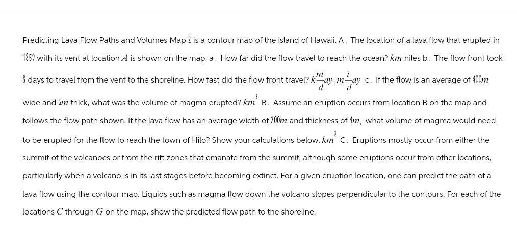
Predicting Lava Flow Paths and Volumes Map 2 is a contour map of the island of Hawaii. A. The location of a lava flow that erupted in 1859 with its vent at location A is shown on the map. a. How far did the flow travel to reach the ocean? km niles b. The flow front took m i 8 days to travel from the vent to the shoreline. How fast did the flow front travel? kay may c. If the flow is an average of 400m d d wide and 5m thick, what was the volume of magma erupted? km B. Assume an eruption occurs from location B on the map and follows the flow path shown. If the lava flow has an average width of 200m and thickness of 4m, what volume of magma would need to be erupted for the flow to reach the town of Hilo? Show your calculations below. km C. Eruptions mostly occur from either the summit of the volcanoes or from the rift zones that emanate from the summit, although some eruptions occur from other locations, particularly when a volcano is in its last stages before becoming extinct. For a given eruption location, one can predict the path of a lava flow using the contour map. Liquids such as magma flow down the volcano slopes perpendicular to the contours. For each of the locations C through G on the map, show the predicted flow path to the shoreline.
Predicting Lava Flow Paths and Volumes Map 2 is a contour map of the island of Hawaii. A. The location of a lava flow that erupted in 1859 with its vent at location A is shown on the map. a. How far did the flow travel to reach the ocean? km niles b. The flow front took m i 8 days to travel from the vent to the shoreline. How fast did the flow front travel? kay may c. If the flow is an average of 400m d d wide and 5m thick, what was the volume of magma erupted? km B. Assume an eruption occurs from location B on the map and follows the flow path shown. If the lava flow has an average width of 200m and thickness of 4m, what volume of magma would need to be erupted for the flow to reach the town of Hilo? Show your calculations below. km C. Eruptions mostly occur from either the summit of the volcanoes or from the rift zones that emanate from the summit, although some eruptions occur from other locations, particularly when a volcano is in its last stages before becoming extinct. For a given eruption location, one can predict the path of a lava flow using the contour map. Liquids such as magma flow down the volcano slopes perpendicular to the contours. For each of the locations C through G on the map, show the predicted flow path to the shoreline.

Applications and Investigations in Earth Science (9th Edition)
9th Edition
ISBN:9780134746241
Author:Edward J. Tarbuck, Frederick K. Lutgens, Dennis G. Tasa
Publisher:Edward J. Tarbuck, Frederick K. Lutgens, Dennis G. Tasa
Chapter1: The Study Of Minerals
Section: Chapter Questions
Problem 1LR

Related questions
Question
Transcribed Image Text:Predicting Lava Flow Paths and Volumes Map 2 is a contour map of the island of Hawaii. A. The location of a lava flow that erupted in
1859 with its vent at location A is shown on the map. a. How far did the flow travel to reach the ocean? km niles b. The flow front took
i
3
m
8 days to travel from the vent to the shoreline. How fast did the flow front travel? kay may c. If the flow is an average of 400m
d d
wide and 5m thick, what was the volume of magma erupted? km B. Assume an eruption occurs from location B on the map and
follows the flow path shown. If the lava flow has an average width of 200m and thickness of 4m, what volume of magma would need
to be erupted for the flow to reach the town of Hilo? Show your calculations below. km C. Eruptions mostly occur from either the
summit of the volcanoes or from the rift zones that emanate from the summit, although some eruptions occur from other locations,
particularly when a volcano is in its last stages before becoming extinct. For a given eruption location, one can predict the path of a
lava flow using the contour map. Liquids such as magma flow down the volcano slopes perpendicular to the contours. For each of the
locations C through G on the map, show the predicted flow path to the shoreline.
Expert Solution
This question has been solved!
Explore an expertly crafted, step-by-step solution for a thorough understanding of key concepts.

This is a popular solution!

Trending now
This is a popular solution!

Step by step
Solved in 3 steps with 4 images

Recommended textbooks for you
Applications and Investigations in Earth Science …
Earth Science
ISBN:
9780134746241
Author:
Edward J. Tarbuck, Frederick K. Lutgens, Dennis G. Tasa
Publisher:
PEARSON

Exercises for Weather & Climate (9th Edition)
Earth Science
ISBN:
9780134041360
Author:
Greg Carbone
Publisher:
PEARSON

Environmental Science
Earth Science
ISBN:
9781260153125
Author:
William P Cunningham Prof., Mary Ann Cunningham Professor
Publisher:
McGraw-Hill Education
Applications and Investigations in Earth Science …
Earth Science
ISBN:
9780134746241
Author:
Edward J. Tarbuck, Frederick K. Lutgens, Dennis G. Tasa
Publisher:
PEARSON
Exercises for Weather & Climate (9th Edition)
Earth Science
ISBN:
9780134041360
Author:
Greg Carbone
Publisher:
PEARSON
Environmental Science
Earth Science
ISBN:
9781260153125
Author:
William P Cunningham Prof., Mary Ann Cunningham Professor
Publisher:
McGraw-Hill Education

Earth Science (15th Edition)
Earth Science
ISBN:
9780134543536
Author:
Edward J. Tarbuck, Frederick K. Lutgens, Dennis G. Tasa
Publisher:
PEARSON

Environmental Science (MindTap Course List)
Earth Science
ISBN:
9781337569613
Author:
G. Tyler Miller, Scott Spoolman
Publisher:
Cengage Learning

Physical Geology
Earth Science
ISBN:
9781259916823
Author:
Plummer, Charles C., CARLSON, Diane H., Hammersley, Lisa
Publisher:
Mcgraw-hill Education,