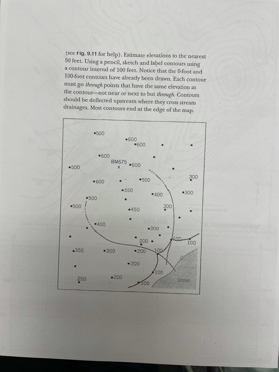
(see Fig. 9.11 for help). Estimate elevations to the nearest 50 feet. Using a pencil, sketch and label contours using a contour interval of 100 feet. Notice that the 0-foot and 100-foot contours have already been drawn. Each contour must go through points that have the same elevation as the contour-not near or next to but through. Contours should be deflected upstream where they cross stream drainages. Most contours end at the edge of the map. •500 •600 •600 •600 BM675 •600 •500 X 300 •500 •600 •550 •300 •400 •500 •500 300 •450 •400 •300 100 100 200 • .350 •300 •200 100 • 200 100 •200 250 Ocean 100
(see Fig. 9.11 for help). Estimate elevations to the nearest 50 feet. Using a pencil, sketch and label contours using a contour interval of 100 feet. Notice that the 0-foot and 100-foot contours have already been drawn. Each contour must go through points that have the same elevation as the contour-not near or next to but through. Contours should be deflected upstream where they cross stream drainages. Most contours end at the edge of the map. •500 •600 •600 •600 BM675 •600 •500 X 300 •500 •600 •550 •300 •400 •500 •500 300 •450 •400 •300 100 100 200 • .350 •300 •200 100 • 200 100 •200 250 Ocean 100
Oh no! Our experts couldn't answer your question.
Don't worry! We won't leave you hanging. Plus, we're giving you back one question for the inconvenience.
Submit your question and receive a step-by-step explanation from our experts in as fast as 30 minutes.
You have no more questions left.
Message from our expert:
Hi and thanks for your question! Unfortunately we cannot answer this particular question due to its complexity.
We've credited a question back to your account. Apologies for the inconvenience.
Your Question:
Transcribed Image Text:(see Fig. 9.11 for help). Estimate elevations to the nearest
50 feet. Using a pencil, sketch and label contours using
a contour interval of 100 feet. Notice that the 0-foot and
100-foot contours have already been drawn. Each contour
must go through points that have the same elevation as
the contour-not near or next to but through. Contours
should be deflected upstream where they cross stream
drainages. Most contours end at the edge of the map.
•500
•600
•600
•600
BM675
•600
•500
X
300
•500
•600
•550
•300
•400
•500
•500
300
•450
•400
•300
100
100
200 •
.350
•300
•200
100
• 200
100
•200
250
Ocean
100

Recommended textbooks for you

Applications and Investigations in Earth Science …
Earth Science
ISBN:
9780134746241
Author:
Edward J. Tarbuck, Frederick K. Lutgens, Dennis G. Tasa
Publisher:
PEARSON

Exercises for Weather & Climate (9th Edition)
Earth Science
ISBN:
9780134041360
Author:
Greg Carbone
Publisher:
PEARSON

Environmental Science
Earth Science
ISBN:
9781260153125
Author:
William P Cunningham Prof., Mary Ann Cunningham Professor
Publisher:
McGraw-Hill Education
Applications and Investigations in Earth Science …
Earth Science
ISBN:
9780134746241
Author:
Edward J. Tarbuck, Frederick K. Lutgens, Dennis G. Tasa
Publisher:
PEARSON
Exercises for Weather & Climate (9th Edition)
Earth Science
ISBN:
9780134041360
Author:
Greg Carbone
Publisher:
PEARSON
Environmental Science
Earth Science
ISBN:
9781260153125
Author:
William P Cunningham Prof., Mary Ann Cunningham Professor
Publisher:
McGraw-Hill Education

Earth Science (15th Edition)
Earth Science
ISBN:
9780134543536
Author:
Edward J. Tarbuck, Frederick K. Lutgens, Dennis G. Tasa
Publisher:
PEARSON

Environmental Science (MindTap Course List)
Earth Science
ISBN:
9781337569613
Author:
G. Tyler Miller, Scott Spoolman
Publisher:
Cengage Learning

Physical Geology
Earth Science
ISBN:
9781259916823
Author:
Plummer, Charles C., CARLSON, Diane H., Hammersley, Lisa
Publisher:
Mcgraw-hill Education,